Difference between revisions of "City Data Model Project Collaboratory Wiki:About"
Megankatsumi (talk | contribs) |
Megankatsumi (talk | contribs) |
||
| Line 1: | Line 1: | ||
A common data model enables city software applications to share information, plan, coordinate, and execute city tasks, and support decision making within and across city services, by providing a precise, unambiguous representation of information and knowledge commonly shared across city services. This requires a clear understanding of the terms used in defining the data, as well as how they relate to one another. This requirement goes beyond syntactic integration (e.g. common data types and protocols), it requires semantic integration: a consistent, shared understanding of the meaning of information. | A common data model enables city software applications to share information, plan, coordinate, and execute city tasks, and support decision making within and across city services, by providing a precise, unambiguous representation of information and knowledge commonly shared across city services. This requires a clear understanding of the terms used in defining the data, as well as how they relate to one another. This requirement goes beyond syntactic integration (e.g. common data types and protocols), it requires semantic integration: a consistent, shared understanding of the meaning of information. | ||
| − | |||
== What is the City Data Model? == | == What is the City Data Model? == | ||
| − | + | City data cover a wide and varied range of concepts. Likewise, uses and sources of this data are numerous and diverse. Different application areas tend to focus on different facets of city data, and so different organizations may attribute different definitions to concepts that describe the same thing. For example, in some applications a Road Segment may be described according to its physical characteristics, whereas other applications may focus on its flow and connectivity to other road segments. | |
The City Data Model represents a long-term goal wherein there exists a shared model of all city-related data. This City Data Model will integrate perspectives from a broad range of standards efforts, with sometimes overlapping or sometimes incompatible semantics. This model will allow anyone to see how their data model “fits in” relative to others’. Organizations will be free to maintain their own models, but can also leverage the City Data Model as a source from which the appropriate data models may be extracted as required. | The City Data Model represents a long-term goal wherein there exists a shared model of all city-related data. This City Data Model will integrate perspectives from a broad range of standards efforts, with sometimes overlapping or sometimes incompatible semantics. This model will allow anyone to see how their data model “fits in” relative to others’. Organizations will be free to maintain their own models, but can also leverage the City Data Model as a source from which the appropriate data models may be extracted as required. | ||
Latest revision as of 20:33, 30 April 2020
A common data model enables city software applications to share information, plan, coordinate, and execute city tasks, and support decision making within and across city services, by providing a precise, unambiguous representation of information and knowledge commonly shared across city services. This requires a clear understanding of the terms used in defining the data, as well as how they relate to one another. This requirement goes beyond syntactic integration (e.g. common data types and protocols), it requires semantic integration: a consistent, shared understanding of the meaning of information.
What is the City Data Model?
City data cover a wide and varied range of concepts. Likewise, uses and sources of this data are numerous and diverse. Different application areas tend to focus on different facets of city data, and so different organizations may attribute different definitions to concepts that describe the same thing. For example, in some applications a Road Segment may be described according to its physical characteristics, whereas other applications may focus on its flow and connectivity to other road segments.
The City Data Model represents a long-term goal wherein there exists a shared model of all city-related data. This City Data Model will integrate perspectives from a broad range of standards efforts, with sometimes overlapping or sometimes incompatible semantics. This model will allow anyone to see how their data model “fits in” relative to others’. Organizations will be free to maintain their own models, but can also leverage the City Data Model as a source from which the appropriate data models may be extracted as required.
This will be achieved by an effort to integrate existing perspectives on city data. Groups involved with city data models will be encouraged to contribute their content in a form that will support alignment with other, heterogeneous views. The result will be an extensive, all-encompassing data model that captures the relationships between different views of the same concept.
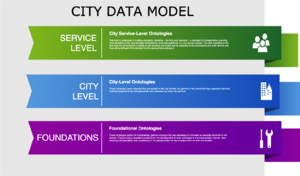
The contents of the City Data Model will be stratified into 3 levels of abstraction (pictured below). The Foundation Level covers very general concepts such as Time, Location, and Activity. The City Level covers concepts that are general to cities and span all services such as Households, Services, Residents. The Service Level spans concepts commonly associated with a particular service but still shared with other services, such as Vehicles and Transportation network. Initial efforts in this collaboratory will focus on the identification and development of the City-level concepts.
What is the a global collaboratory?
The Collaboratory is a tool to support the creation of the city data model. It houses the conversation on what concepts should be included, and how different concepts from different groups are related to one another. The purpose of this collaboratory is to provide an environment wherein individuals from related standards organizations and other stakeholders can openly contribute to the development of a standard model for city data. It is maintained by the University of Toronto’s School of Cities and Enterprise Integration Laboratory.
